Living in Southwest Colorado means experiencing all four seasons, and seeing how each one influences the next. Spring runoff is one of the clearest examples of this transition. It marks the shift from winter to summer, bringing melted snow from the high mountains into our rivers and streams. Here’s a look at spring runoff in Durango and how it impacts our area.
What is Spring Runoff?
As the weather gets warmer, the dense snowpack in the San Juan Mountains to the north of Durango begins to melt. Ultimately, a lot of this snowmelt makes its way into the Animas River which winds through the Animas Valley and Durango and continues south. The San Juan River, part of the San Juan Basin, also benefits from this seasonal snowmelt. Although runoff begins in the spring, much of the effect (higher water flows) are most notable in the early summer. Springtime rain showers also contribute additional water to our rivers and streams. This pattern isn’t unique to Colorado; it occurs around the world in different watersheds and river basins.
Measuring the Animas River
River flow is typically measured in cubic feet per second (cfs), which is a standard hydrologic unit. It may also be monitored by river height in feet at consistent measurement points - in Durango, this is measured near 14th and Main. For context, the highest recorded cfs since 2010 occurred in June 2019, peaking at 7070 cfs. In contrast, the Animas usually runs between 100- 200 cfs in the winter. Heavy snowfall years, like 2019, 2020, and 2023, lead to stronger runoff, while lighter snowfall years, such as 2018, 2022, 2024, result in a lower peak flow.
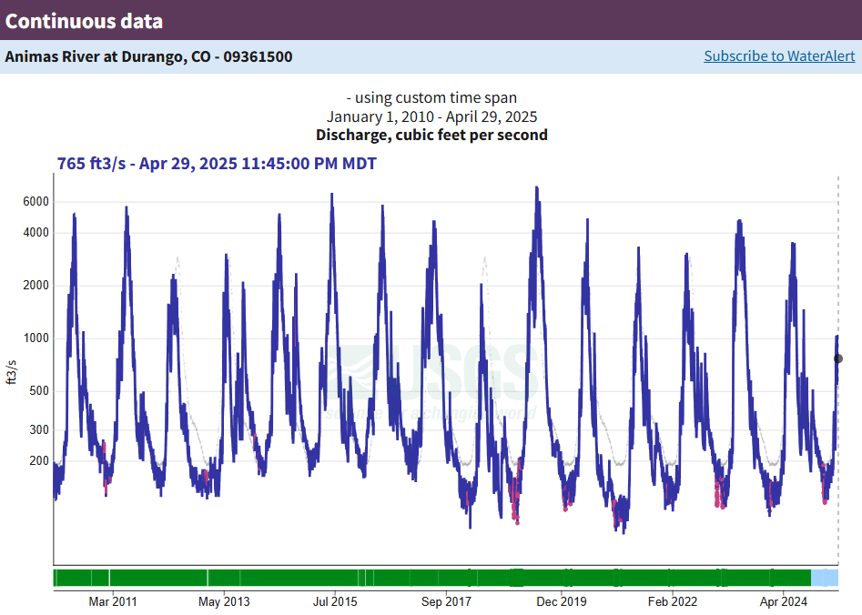
2025 Spring Runoff in Durango
This year, the runoff started gaining momentum in early April, right on schedule. However, due to above-average temperatures - with several days reaching 60-70 degrees - runoff has accelerated more quickly than usual. Combined with a lighter than average snowpack, 2025’s runoff is expected to be shorter and less intense than in previous years. For comparison, 2024 saw a peak flow of 3440 cfs, and current predictions suggest we may not surpass that this season. You can track our river’s data on the USGS site.
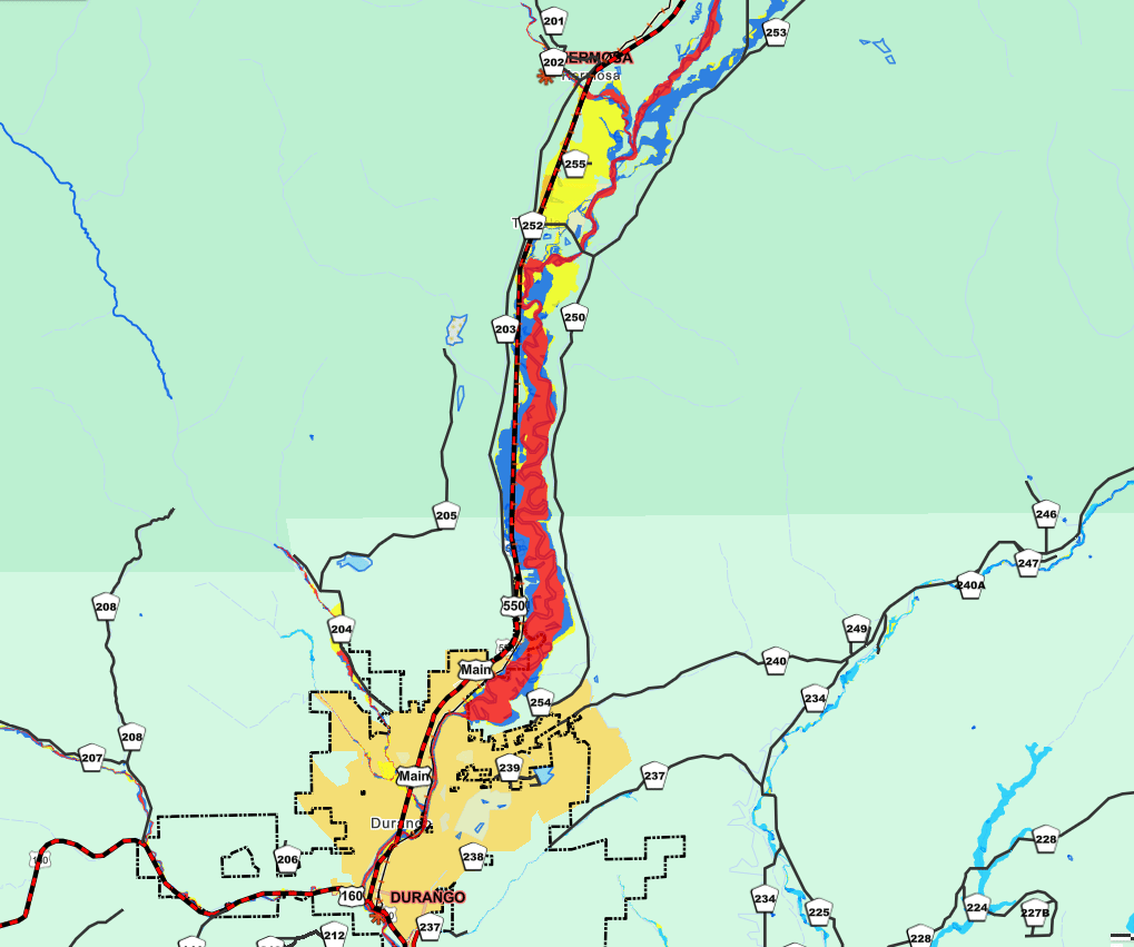
Flood Zones
In real estate, understanding flood zones is especially important for properties near water. Durango and the surrounding areas feature amazing riverfront properties and those located within the river valleys, which brings additional factors to consider. Flood zones are split into 100-year (higher risk - red zone) and 500-year areas (moderate risk - blue zone), which are determined by the statistical probability of being flooded each year. For property within the 100-year flood zone, flood insurance is required by most lenders due to the added risk. Any new construction in this zone requires an elevation certificate and mandates that the structure be built above the base flood elevation. Durango’s Animas Valley, with its flat terrain and winding river, contains many of these floodplain areas. Some homes were built before modern regulations and may sit closer to the water than is currently allowable today.
Spring runoff is a reminder of how interconnected our seasons are - and how these natural cycles shape the landscape and community we live in. If you have any questions about living near the river, or want to explore waterfront properties in Southwest Colorado, we are here to help!
Start your waterfront property search here.